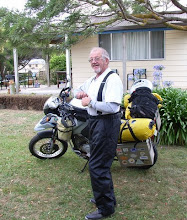
Saturday, July 31, 2010

US/Canada Travels for 31 July 2010

Idaho, Nevada, Oregon, Washington

Running south on route 93 from Montana we cross the border at the Loss Trail Pass, 7014 ft, into Idaho for our next segment of chasing the Geocaching containers. Driving down the Bitterroot Mountains and the Salmon National Forest is all what your tourist brochures brag about. Beautiful scenery at every turn.

Then we come into the Craters of the Moon National Monument. The temperature at this time of day (1430hrs) is just around 108 degrees F (me thinks 38 C). It's a campsite for the next 2 days and for the first time since I've had the Goatmobile the air conditioner comes on and stays on. Found a 50-mile bit of gravel road that I was hoping for the stray 4-legged animal but the only thing that showed any interest was a Desert Fox laying in the shade of a horse watering troth. Did find three vertical stone column's over a space of 20 miles that meant ……………

Back to the Craters of the Moon, once the sunset, the wind dropped, the temperature was in the high 80's, and life took on a new meaning. It was so peaceful, quite, bug free and the cuppa of red wine with the hummus, give me that lap pool with the 50-inch telly and I could stay here forever. Spent another day traveling the gravel roads around the Crater Monument. Spotted 3 adult pronghorn antelope with young and another adult later in my travels.

Tomorrow its south on Route 93 into the Sawtooth National Forest Geocaching as I go. And it is the Sawtooth National Forest with 4 Geocaches within its bounties'. The first 2 were accessible but number 3 & 4 meant that I was going to have to cross a very deep and muddy hole. In me younger days this would be doable but when you are 30 miles from anyone, alone and in the Goatmobile some how common sense (very little) comes into play. We turn around find a decent campsite, breakout the cardboard box of the finest red wine available, chew beef jerky and crank up the speakers listening to Madama Butterfly (Puccini) and Rinaldo (Handel).
Man I have the grizzly's, black bears, and elk dancing the mambo with a bit of Elvis thrown in. While resting me cuppa on a very old pile of elk scat……….

Awoke the next morning to a coyotes giving his best at 0500 hrs to his neighbors. Down the gravel road to the first Geocache for the day and with a final count of ten and setting up camp on the old pony express trail for the night. Well the campsite did not last the night out. Heard too many noises that were not in my sound card. It was up and out of there to a more populated area where I could rest a lot easier.

One thing about being in a hot dry desert environment, you don't sweat, which of course means we go a lot longer between showers. My normal 10-day no shower routine can now stretch to 15 days, which lessens my carbon footprint generating more water to make beer.

If for any reason you do follow Route 93, there is the Mt. Wilson Back County Byway, which I didn't take, it has all those dots along its path which tells you that it has all the views and wildlife that anyone could wish for. Another place that is not advertised on Route 93 is the Pahranagat National Wildlife Refuge. It sits on a lake and there is camping. Following 93 down to Las Vegas, 110-degree temps hit you along with long straight boring bloody road. The good thing about Vegas is once there you are heading north, north to cooler climates, north to mosquito's and Alaska.

We follow Route 95 out of Las Vegas up to Hawthorne where temps have been 110 again and even at night 100 is the norm. Even sleeping naked you are wearing too much. From Hawthorne its north to Fallon Naval Air Station where there is a RV site, showers, free laundry, air condition spaces to mellow out…………While at Fallon took route 50 to Sand Mountain. A very, very big pile of sand in the middle of nowhere. The road driving in was firm but once there, believe me; thinking that you can drive anywhere is going to be a very big mistake. Even the parking lot was a bit soft for the Goatmobile. Back out to Route 50 to 116 to the Stillwater National Wildlife Refuge for a quick auto tour, hot as hell but doable.

Continue north on Route 95 and you are going to enter into the Humboldt-Toiyabe National Forest. There is only one sign indicating a campsite along with some other sites. Turn right and follow the dirt road into the canyon and up to 6000 ft plus. The scenery is just incredible and if you are looking for a campsite why it's just another 15 miles of gravel. I decided to just camp out at the top of the pass for the night. The sun was shinning, wind at 5-10 knots, wine in hand along with another New York Times Best Seller. This peaceful scenario did not last long, first the wind picked up, next rain, thunderclouds and finally lightning. Being as I am sitting by myself at 6000 ft and being the only piece of metal around, it was everything into the Goatmobile and down the hill I went and finding a spot with my neighbors for (cows) the night.
Next day has me crossing the state line of Oregon and spending the night with old friends from Midway Atoll, Hawaiian Islands.

Next day we continue north Geocaching and spending another night at a National Forest. After a proper cup of coffee and lies abound I head north following the path of very little guidance. Route 3 it is going north into Washington State. Route 3 and 129 provide more twist and turns then the good lord allows. Matter of fact there is a huge motorcycle rally in August for bikers that make that particular trek. I am assuming that there will be plenty of beer, comradeship, and BS. At the bottom of all the turns and twist's is Brogan's. Great place for ice cream sundaes and a Geocache. They have been there since the turn of the century and will remain for another 100 years. The temp at the bottom of the gorge had to be a 100 plus, even though there was free camping my thoughts were onto a state park just out of the gorge and a hot shower.

Next morning we find ourselves heading north via routes 129,12,261 and 21. Western Washington is wheat, wheat, and more wheat. Thinking that I had seen farmland in North Dakota, nothing prepared me for Washington State. It just goes on and on from one horizon to another. The only saving grace is that it is not flat and the roads do have a bit of life to them. It's the town of Wilbur that has me stopping for the night with a bit of blue grass music to soothe the nerves from a long day on the road.

We are onto the border this last day of the month for July, mileage for the Goatmobile is 17,500 miles, and we have British Columbia, Yukon, and Alaska ahead of us.

Aloha

Norm

Friday, July 16, 2010

WARNING!!!


Subject: Fwd: WARNING!!!

!!!

ALIENS ARE COMING TO EARTH NEXT THURSDAY AND THEIR MISSION IS TO ABDUCT ALL GOOD LOOKING AND SEXY "OLD" PEOPLE. 
 
YOU WILL BE SAFE ; I'M JUST E-MAILING YOU TO SAY GOODBYE.
 
 
(LOL!!!)

Thursday, July 15, 2010

US/Canada Travel Log for 7.15.2010

Ontario, Minnesota, North Dakota, Montana

And its 1 July, Canada day, same as our 4 July but with less BS. Looking east at 0430hrs the sun was just about to make its appearance and the sunrise was going to be spectacular but Mother Nature cancelled the sunrise with a solid layer of fog until 0800hrs.

I continue working west along route 17 with Lake Superior on the horizon caching as I go, Thunder Bay is still another day off but who is counting. It was another great day for weather, can this really be happening, but we will find out believe me.

I am now in central time zone moving west from Thunder Bay and summer is here with today's temps in the 30's C. All of my winter gear is being boosted up to the cargo carrier; this will allow me to store more of that fine cold beer down below for emergencies. Tonight I stop in a provincial park, the humidity is neigh high, and the twits have fires going……..is there something wrong with this picture? But fear not, Mother Nature took care of this problem with thunderstorms, lightning, wind, and rain (2.5 inches /60mm). Now they are all locked in the caravan with the kids, grand parents, and the dog. This morn was wet, things were put away wet, and for my first cuppa, the woman was explaining to me that the reason the tent sites were burning wood when both the heat and humidity was over the scale "was to dry out the air".

Any way with that bit of information, the first Geocache was in the middle of a downpour. Thinking that it should be a quickie, wrong, soaked to the gills with a no find. Next one was again in the wet; me thinking at this time, screw it I am wet and I really don't need to add any more water to the clothes. Head for Safeway in Fort Williams were Starbucks is with access to Wi-Fi. Wrong again so over the border at the International Falls, Minnesota and a fill up at the gas station for half the price. Now I am heading west on route 11 when we have a detour, this detour cost me in mileage just about 100 miles and counting. Fortunately I found a local lad who put me on the county road system but still it was 100 miles plus by the time I got to Pine Island State Park. Most national and state parks like to put you in the quite, green environment. Well this also leads to a great abundance of black flies and mosquito's and finding that this was going to be
a major problem and not wanting to be part of the food chain, I was out of there.

The area that I've been passing through in Ontario for the last days is in total un-employment shut down. The last wood mill had shut down and unemployment went up by 10,000 souls. There is nothing on the horizon either except some gold and platinum companies who are making exploratory drilling. But for anything substantial, it is still years away.

And should I remind everyone that mosquitoes do not exist in Minnesota, no it's the bloody state bird. Geocaching has exposed me to the worst of worst of mosquito's bites. I do not care how much you spray yourself with DEET; the bloody suckers will find an opening somewhere.
Last night here I was at a small picnic area, next we find ourselves inundated with people from farms on both sides of the area. Just a fantastic group and meeting a coupler that was with the first group of Peace Corp flower children volunteers to go forth in the early 60's. There are a few of them left, one in particular hiding on a remote pacific atoll. Geocaching all day long brings me to Lake Branson where the breeze is doable and the bugs are a big part of the scene. If you do check into a state park make sure and I mean make sure you get a campsite at the windiest part of the park or you will be a blood bank provider for the mosquitos. Another thought of caution when traveling; check out the bathroom facilities before committing yourself to a campsite. You will be surprised at the number of places that charge you to the max and the bathrooms would not qualify for a loo in Calcutta.

North Dakota and its radio station 105.1 for country. Did I mention that upper Minnesota is flat, the roads are straight, well North Dakota is nothing but an extension of the same. The highest thing seen to date is the McDonalds Arch……..
After a very serious conversation with one of the farmers in ND, he informed me that as an export crop they grow mosquitoes especially in wheat fields where I just so happen to be looking for me small container. A little known factoid; ND has a positive cash flow and the reason is oil, you know that stuff that's running $80.00 a barrel, has been discovered in western ND. With a population of 650,000, no worries on expenditures either.

Oil in western North Dakota is both a blessing and a curse. The sudden wealth to the farmer who by most standards was poorer then a bloody church mouse now are the SUV groupie. The impact on the infrastructure is another story all together. All of the roads either gravel or sealed were structured for the farming community. Now add trucks, a lot of trucks carrying tons and tons of equipment to support the oil fields, the road system starts to break down. And did I mention people and housing; non-existent and probably won't be corrected for a number of years. If you are single and want to make a lot of money, west North Dakota and east Montana are the place to be.
The ratio of men to women in the oil fields is 50 to 1. So ladies, if you can breath, cook an apple pie and cut a cord of wood during the winter months, the possibilities are there for that perfect match of a lifetime.

My last night stay in North Dakota is at the National Forest Buffalo Gap Camp on route 94. Most National Forest sites are primitive, water and loo, but for $3.00 a night how can you go wrong. So in the morn it's over the border into the Big Sky country of Montana. Five hours later I am standing at the Billings, Montana Costco store and its good to be back.

North to the Lewis and Clark National Forest it is and is it big country. Impressed I was with North Dakota; Montana with its mountains and vast open spaces will be worth every mosquito and deer fly bite. Did I mention ticks, no, well let me tell you those little suckers are alive and well. My total to date is 6 and hopefully there is no Lyme disease among the group.
We get ourselves through Missoula into the worst traffic while in Montana, route 93 south. They are widening the road and it's just a miserable trip for 40 miles south. Lake Como, National Forest, and another $4.00 night with Idaho on the horizon.

Aloha,

Norm

The Greynomad

Monday, July 5, 2010

Bacon Tree


Two Mexicans are stuck in the desert after crossing into the United States, wandering aimlessly and starving. They are about to just lie down and wait for death, when all of a sudden Luis says.........

"Hey Pepe, do you smell what I smell.  Ees bacon, I theenk."

"Si, Luis, eet sure smells like bacon. "

With renewed hope they struggle up the next sand dune, & there, in the distance, is a tree loaded with bacon.

There's raw bacon, there's fried bacon, back bacon, double smoked bacon, Canadian bacon ... every imaginable kind of cured pork.

"Pepe, Pepe, we ees saved.  Ees a bacon tree."

"Luis, maybe ees a meerage?  We ees in the desert don't  forget."

"Pepe, since when deed you ever hear of  a meerage that smell like bacon...ees no meerage, ees a bacon tree."

And with that, Luis staggers towards the tree.  He gets to within 5 meters, Pepe crawling close behind, when suddenly a machine gun opens up, and Luis drops like a wet sock.  Mortally wounded, he warns Pepe with his dying breath,

"Pepe... go back man, you was right, ees not a bacon tree!"

"Luis, Luis mi amigo... what ees it? "

"Pepe.. ees not a bacon tree.
 
Ees
 
Ees
 
Ees
 
Ees
 
Ees
 
Ees a ham bush..."
 
 
Sorry. I know there mush be something wrong with me for sending you this.   It was those little voices that made me do it. I couldn't help it.
 
But admit it.  You tried reading this with an accent.  I know you did.  Your voices already told mine. Quit squirming.